AIM Robotics
DJI Matrice 4TD (RC Plus 2)
DJI Matrice 4TD (RC Plus 2)
Regular price
$11,519.00 CAD
Regular price
Sale price
$11,519.00 CAD
Unit price
per
Shipping calculated at checkout.
Low stock: 5 left
Couldn't load pickup availability
The DJI Matrice 4TD is an all-new water and dust-resistant industrial drone engineered for thermal imaging, infrastructure inspections, and public safety applications. Designed to integrate seamlessly with the DJI Dock 3 or operate independently with the DJI RC Plus 2 Enterprise, the Matrice 4TD delivers cutting-edge aerial intelligence with superior imaging capabilities.
Batteries sold separately
|
Product Name
|
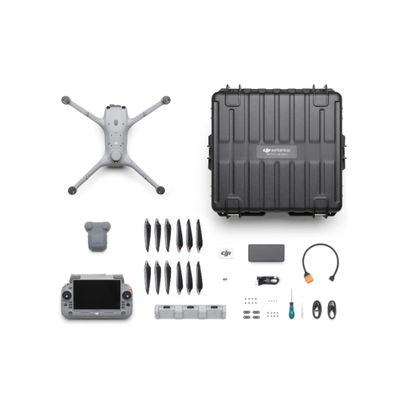
In-the-box info
|
|
DJI Matrice 4D/M4TD (DJI RC Plus 2 Enterprise (NA)) SP Plus
|
DJI Matrice 4D/4TD (DJI RC Plus 2 Enterprise(Overseas Edition)
|
|
DJI Care Enterprise Plus Auto-Activated(DJI Matrice 4D/4TD) NA
|
|
|
DJI 240W Power Adapter
|
|
|
DJI Matrice 4D Series 240W Charging Hub
|
|
|
DJI Matrice 4D Series Carrying Case
|
|
|
DJI RC Plus 2
|
Key Features:
- Extended Flight Time & Robust Protection – Up to 47 minutes of flight time with an IP55 dust and water resistance rating, ensuring reliable performance in extreme conditions.
- Advanced Multi-Sensor System – Features a wide-angle, medium tele, and tele camera, along with an integrated Laser Range Finder and Infrared Thermal Camera for unparalleled imaging capabilities.
- Laser Range Finder – Provides a measurement range of 1800m (1 Hz), oblique incidence range of 600m (1 Hz), and an accuracy of ± (0.2 + 0.0015 × D).
- Infrared Thermal Camera – Offers 640×512 resolution, f/1.0 aperture, 53mm format equivalent, and an Uncooled VOx Microbolometer with UHR Infrared Image mode for high-resolution thermal imaging.
- NIR Auxiliary Light – Features a 6° FOV with a 100m illumination distance, enhancing nighttime and low-light operations.
- Advanced Obstacle Avoidance – Utilizes rotating LiDAR and millimeter-wave radar (Sold Separately) for precise 12mm wire-level obstacle detection, ensuring safe flight in complex environments.
- Extreme Weather Resilience – Operates in temperatures ranging from -30°C (-22°F) to 50°C (122°F) and withstands wind speeds up to 12 m/s.
- Standalone or Dock-Integrated Use – Pair with DJI RC Plus 2 Enterprise for manual control or integrate with DJI Dock 3 for fully automated remote deployment.
- Long-Range Data Transmission – Advanced transmission capabilities allow seamless operation up to 25 km away when paired with the D-RTK 3 Relay.
Professional Imaging System
- Wide-Angle Camera: 4/3 CMOS, 20MP, f/2.8-f/11, 24mm format equivalent, mechanical shutter.
- Medium Tele Camera: 1/1.3-inch CMOS, 48MP, f/2.8, 70mm format equivalent.
- Tele Camera: 1/1.5-inch CMOS, 48MP, f/2.8, 168mm format equivalent.
- Laser Range Finder: Measurement range up to 1800m, accurate distance calculation with real-time data integration.
- Infrared Thermal Camera: 640×512 resolution, f/1.0 aperture, 53mm format equivalent, Uncooled VOx Microbolometer, UHR Infrared Image mode.
- NIR Auxiliary Light: 6° FOV, 100m illumination distance for enhanced low-light operations.
Optimized for Precision Mapping & Inspections
- 5-Direction Oblique Photography & 3-Direction Orthophoto Photography – Ideal for detailed aerial mapping and digital twin creation.
- Enhanced Stabilization & 10x Zoom Clarity – Maintain clear images and precise details even at long distances.
- Real-Time Terrain Following & Smart 3D Capture – Achieve industry-leading photogrammetry and modeling accuracy.
Enhanced Operational Safety
- 360° Obstacle Sensing with AI-Based Avoidance (Sold Separately) – Powered by LiDAR and millimeter-wave radar for superior navigation.
- Cloud-Based Fleet Management with DJI FlightHub 2 – Automate flight routes, monitor live feeds, and manage data securely.
- Auto-Relay System for Mountainous Terrain (Sold Separately) – Utilize one drone as a relay for extended range and coverage.
Industry Applications
- Public Safety & Search & Rescue – Real-time aerial intelligence and thermal imaging for emergency response teams.
- Powerline & Infrastructure Inspections – Detect fine details such as pin cracks and wiring anomalies at a distance.
- Geospatial & Aerial Mapping – High-precision imaging and automation for topographic surveys.
- Oil, Gas & Renewable Energy Monitoring – Enhance asset inspection with AI-driven flight automation.
- Nighttime & Low-Light Operations – Enhanced with NIR auxiliary light and infrared thermal imaging for round-the-clock missions.